Spring in Oregon is an excellent time to see waterfalls! Melting Winter snow and Spring rains mean that the rivers and streams will be full, and the forests will be lush and green.
Some of Oregon’s most popular waterfalls can be busy this time of year. Traffic along Oregon’s Columbia Gorge Waterfall Corridor has increased to the point that ODOT will now be requiring permits for the route between May 24th and Labor Day.
Almost everyone in Oregon is familiar with Multnomah Falls and Silver Falls, and other places like Bridal Veil Falls and Salt Creek Falls are also popular destinations. Other waterfalls, some also very spectacular, provide the opportunity to enjoy these natural wonders with fewer crowds, and no fees to pay.
Hikes vary in difficulty and length; many are suitable for family outings and may have limited facilities such as vault toilets or picnic areas. Here are some places around the State to consider visiting this Spring.
Northwest Oregon
Munson Creek Falls in the Tillamook State Forest is the tallest waterfall in the coast range. An easy, ¼ mile trail through old-growth forest leads to a viewing area. In the Spring, look for native wildflowers like trillium and violas. The park is open for day use year-round, and there is no day use fee for this park.
Directions from Tillamook: Take Highway 101 South about 7 miles to Pleasant Valley and turn left on Munson Creek Road. After about 1 mile, turn left to stay on Munson Creek Road. After about ¼ mile, take the right fork for Munson Creek State Park.
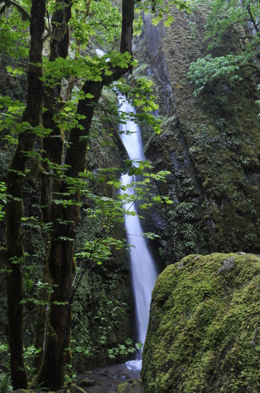
Oregon’s Niagara Falls: This scenic waterfall trail includes both Niagara falls and Pheasant Creek Falls. Located in the Siuslaw National Forest, in the Cascade mountain range, this 2-mile trail is relatively easy and family-friendly. However, the trail does have an overall 455-ft elevation change; the hike in is all downhill, and then the return is uphill.
Directions from Sheridan: The road is long and windy, with lots of turns, so the trip may take longer than expected. From Highway 18, take the exit to S Bridge Street. Turn left from S Bridge Street onto Willamina Sheridan Highway, then right onto Rock Creek Road. After 4.5 miles, turn left onto Buck Hollow Road. At the T, Turn right onto Willamina Creek Road. Turn left onto Coast Creek Road, then right onto Gilbert Creek Road. Turn Right onto SW Bald Mountain Road. Turn left onto SW Bible Creek Road. Turn left onto Forest Service Road NF-14. Take a right at the T to stay on NF-14. A trail map is available on the forest service website.
Southern Oregon
Wolf Creek Falls: Located on BLM-managed land just outside the Umpqua National Forest, Wolf Creek Falls is a two-tier, 75-foot waterfall that puts on a massive display in the Spring. There is parking, a picnic area, and restrooms at the trailhead, and the trail is disabled-accessible for the first ½ mile section, which ends at a picnic site. Afterwards, the trail becomes moderately difficult with steeper slopes. Old growth firs shade the trail, and the light in the Spring is ideal for photography. The park is open year-round and no fee or permit is needed. The BLM has a brochure covering the area.
Directions from Glide: From Highway 138, take Little River Road for 10.7 miles to the trailhead (on the right).
Mill and Barr Creek Falls Trailhead: Mill and Barr Creek Falls Trailhead is located at Prospect State Park between Medford and Crater Lake, just before the town of Prospect along the Rogue River. Currently managed by Jackson County Parks, there is little information online – but the park is open, and the 1.4-mile easy hike includes views of both Mill Creek Falls (173 ft) and Barr Creek Falls (240 ft). While this is a family-friendly hike, there are cliffs and drop-offs along the way of which to be cautious. A picnic area and restrooms are located a short way further up Mill Creek Drive.
Directions from Medford: Take Highway 62 (Crater Lake Highway) 42.5 miles, then turn right on Prospect Access Road. After about 1/3 mile, turn right on Mill Creek Drive and go about 1 mile to the trailhead (on the right). No fee or permit required.
Gold and Silver Falls State Natural Area: This gem of a park in Southern Oregon is a little off the beaten path, but is worth the drive if you are over on the Southern Oregon Coast. The hike is pretty, and the forest includes a variety of trees including firs, maples, alders, and myrtle. The 1.2-mile trail is well maintained and suitable for all skill levels, but the road in is a bit rough so be prepared to encounter potholes. The last few miles leading to the park are a one-lane, gravel road.
Directions from Coos Bay: Take OR-241 22 miles to Glenn Creek Rd, and then continue on Glenn Creek Rd for 2.4 miles to the park.
Central Oregon
White River Falls State Park: In Central Oregon, these falls plunge 90 feet over basalt cliffs into a canyon. The scene is very picturesque, so you are sure to get some good shots. The short trail from the parking area is a steep, rough descent into the canyon to the historic hydroelectric plant at the base of the falls. The trail continues to the lower falls. The entire route is less than a mile. The park is open year-round, but the main parking lot and restrooms are closed in Winter. There is no fee.
Directions from The Dalles: Take Highway 197 South about 28 miles and then turn left on Highway 216/Sherars Bridge Highway. The turn for White River Falls State Park is in about 4 miles, on the right. You can also reach Highway 216 from the South by taking HIghway 197 North out of Maupin.
Fall River Falls: In LaPine State Park there are more than 14 miles of hiking trails. The 4.4-mile Fall River Loop to the small, tumbling waterfall starts at the park’s day-use area. The stub trail leading to the falls is a left turn about a half-mile into the hike. The trail is easy and suitable for all skill levels. While the park is open year-round, the day-use area is closed in winter. Access before May 1st is from the McGregor Memorial Viewpoint at the South end of the park. There are no day-use parking fees.
Directions from Bend: Take Highway 97S to State Recreation Road to the park, and follow signs to the day-use parking area.
Willamette Valley
The Soda Falls Trail at Cascadia State Park (Open May to September) is a short (.75-mile), easy trail that begins from the group camping area adjacent to the day use parking. The park is about 20 miles east of Sweethome, in the hills of the Cascade Mountains, just outside the boundaries of the WIlamette National Forest. The three tiers of water rain down from a basalt ledge 134 feet above. The waterfall is most majestic during the Spring when the snow runoff from the mountains fills the creek.
Directions from Sweet Home: Take Highway 20E to Cascadia and turn left on Cascadia Dr.; the park is on the right.
McDowell Creek Falls Park is a hidden gem about 16 miles southeast of Lebanon with several miles of hiking trails, restrooms, and picnic facilities. There are actually four waterfalls in the park to see. Straight down stone steps from the upper parking area, you can view the beautiful Majestic Falls. Take the 1.6-mile loop hiking trail to then see Crystal Falls, and Royal Terrace Falls. Lower McDowell Creek Falls can be viewed from the base by going through the picnic area near the lower parking area, to the stream.
Directions from Lebanon: Take Highway 20E from Lebanon to Old Santiam Highway and turn left. Take the first right onto Fairview Rd. In about 1 mile, turn left onto McDowell Creek Drive. Drive 8 miles to the park entrance, on the right.
Thank you so much for detailed information on the Oregon water falls and parks. Water Falls are so nice to take a day trip to see these wonderful Falls.